|
The Sublette County Journal Volume 4, Number 13 - 11/24/99 brought to you online by Pinedale Online
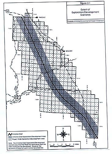
BLM analyzes impacts from up to 900 natural gas wells south of Pinedale by Rob Shaul The much delayed Draft Environmental Impact Statement (DEIS) for the Pinedale Anticline Natural Gas Project was finally released last week for public review and comment. The DEIS is over 600 pages several hundred pages long and is a phone book-sized 1 1/2 inches thick. The BLM analyzed the environmental and economic impacts from up to 900 new natural gas wells that could be drilled on the Mesa south of Pinedale over the next 10-15 years. Two different development scenarios, number of wells that could be drilled and mitigation alternatives were analyzed in the document. Highlighted below are the major issues discussed in the document: Development Will Most Likely Occur Along Anticline Crest While the BLM analyzed the effects from drilling across the entire 197,345-acre project area, drilling will most likely be concentrated in a 2-mile wide strip which runs along the spine of the Pinedale Anticline from the Jonah II field to just west of town. According to the document, of all the 41 exploratory wells that have been drilled on the Mesa thus far, the only wells that have been economical have been on or near the Anticline Crest. The wells drilled away from the crest have been dry holes. Operators Disagree On The Number of Wells Needed The numerous oil and gas operators who have leases in the project area disagree on the number of wells that will need to be drilled to drain the natural gas reservoir. Ultra Petroleum believes over 700 producing wells will be needed while McMurry Oil believes just 300-350 wells will do the job. The BLM tends to agree with McMurry, but analyzed the impacts from 900 wells to err on the cautious side. Visibility Is A Non-Issue The major environmental issue that stood in the way of both the Pinedale Anticline and Jonah II natural gas projects was the development's impacts on visibility above the Bridger Wilderness. The air above the wilderness is a Class I airshed, and any degradation in visibility would be a violation of the Clean Air Act. The problem with the natural gas projects were emissions from the large compressor stations that are used to compress and force the natural gas from the wells down the pipeline to Opal. Impacts to the Bridger Wilderness airshed from the Anticline project were estimated to be below the U.S. Forest Service's level of concern - thus making air quality a non-issue in terms of this project. BLM May Slow the Pace of Development In the analysis, the BLM discusses taking action to slow the pace of development by restricting the number of drilling rigs that can be operating at one time. The agency reasons that slowing the pace of drilling will decrease traffic, surface impact, and emissions from the project. Without drill rig restrictions, the BLM assumes 8 rigs would be drilling on the anticline year-round. These rigs would drill 60-90 rigs annually over a 10-15 year period. For the purposes of analysis, the BLM proposes limiting the number of rigs working in the project area at any one time to no more than five rigs. Eighty percent of the land in the project area is federal land - or under the jurisdiction of the BLM, however the agency would also work to limit the number of rigs operating on state and private lands to maintain a total maximum of five working at one time. No Drilling During Seasonal Closures No drilling will be allowed in areas on the Mesa which have seasonal constraints. Seasonal restraints are currently imposed on areas of big game crucial winter range between November 15 and April 30 and sage grouse nesting habitat and leks between March 1 and June 30. However, the oil and gas companies will be able to visit wells in these areas for daily maintenance during the restriction period. The possibility of plowing the Mesa Road to facilitate these visits is being considered. New Roads & Traffic The major environmental impact to the Mesa from the Anticline Project will be the construction of new roads and the related traffic. The DEIS estimates up to 200 miles of new roads will be constructed over the project's life to service well pads and compression facilities. The analysis assumes that the proposed road up the spine of the Anticline, and a road leading to the project from the county Industrial Site west of town will be constructed. Traffic will also be significant. The DEIS assumes the typical well will take 30-35 days to complete. If 8 rigs are allowed to drill simultaneously, the resulting traffic would be 110 heavy vehicle and 190 light vehicle round-trips to the project area daily. This adds up to 300 vehicle round trips daily. If the BLM decides to slow the pace of development and allows just 5 rigs to drill at one time, the total traffic decreases by over 50%. Sixty heavy vehicle and eighty light vehicle round-trips would be required daily, for a total traffic load of 140 daily round-trips. The DEIS calls for the development of a Transportation Committee to address new road and traffic issues and make recommendations to the BLM. Residential Subdivision Impact Greatest from Drilling on Private Land Approximately 2,085 acres of the Anticline Project area have been zoned residential, and there are 32 separate subdivided areas that partially overlap the project area. According to the DEIS, there are 233 potential well pad locations on federal land within a quarter-mile of subdivisions or subdivided land. Under one alternative, the BLM would impose a quarter-mile buffer around occupied dwellings. This would eliminate 51 of the potential well pads. However, the BLM has no control over drilling on private lands which are closest to the subdivisions. There are 196 potential well pad locations on private and state lands near residential subdivisions - meaning impacts to residences could still occur. Mule Deer Crucial Winter Range The Anticline Project's impact on big game crucial winter range has emerged as one of the most important environmental issues facing the project. Approximately 27,220 acres of the project area is also mule deer crucial winter range for the Sublette Mule Deer Herd Unit. In 1997, the Game & Fish estimated there were 24,700 deer in the herd that has a population objective of 32,000 animals. The DEIS acknowledges that there will be impacts to the deer crucial winter range. These include surface disturbance through roads and well pads, along with possible disturbance during the winter from vehicles servicing well sites. The BLM proposes several actions to mitigate impacts to deer. First, it suggests well pads should not be placed in the Mesa Breaks area on the east edge of the Mesa. It also suggests limiting well density to 4 pads/section within the mule deer winter and crucial winter ranges. Further, one of the larger mitigating steps could be to require the oil and gas companies to put in centralized processing facilities or CPFs. One centralized facility would be required for every 16 pads, but would eliminate the need to visit wells on a daily basis during the winter. CPFs would also decrease the needed well pad size from 1.5 acres to just .5 acre, thus cutting by two-thirds well pad surface disturbance. Sage Grouse There are 44 sage grouse leks within the Anticline area. To protect the birds, the BLM proposes limiting well pad densities to 4 pads/section within high quality sage grouse nesting habitat and establishing a quarter-mile buffer zone for surface disturbance around leks. Further, in the spring when the grouse are strutting on the leks, the BLM proposes to limit noise disturbance between midnight and 9 a.m. so that no more than a 10-decibel increase in background noise occurs at the lek. This means that drilling rigs within two miles of a lek would have to shut down operations from midnight to 9 a.m. Finally, the BLM has proposed several studies to determine if quarter-mile buffers around leks are sufficient to mitigate impacts from development. Seeing Development from Pinedale The BLM suggests preventing any drilling within the 5,200 acres of the northeastern edge of the project that has been designated as a "VRM Class II Viewshed" until the BLM and the operators develop a plan to mitigate any impacts from development to the view from Pinedale and surrounding areas. In practical terms, this means 82 wells will be delayed from being drilled on federal lands within the VRM Class II Viewshed until this plan is developed. Once this plan is developed, the BLM wants to limit well density to 4 pads/section. However, the agency can only regulate well on federal lands. The agency has no say on wells that are located on private lands close to Pinedale. Economic Impacts The BLM lists some impressive economic impacts from the proposed drilling. The typical Anticline well will generate annual gross revenue of $1.3 million and pay an average of $285,000 per year in property taxes. Of these taxes, $19,000 would go into the county government coffers and $47,000 would go towards supporting schools statewide. Fifty Anticline wells will generate $1 million for county government and $2 million for schools statewide. In addition to property taxes, each well will generate $67,000 in sales taxes, of which $18,000 would return to the county and town governments in Sublette County. At its peak, the project will require a workforce of between 320 and 186 people. This does not count the other jobs and economic activity in the town and county which would supported by the project. Comment Period and Final Decision The public will be able to comment on the Pinedale Anticline DEIS through January 25, 2000. According to project manager Bill McMahan, the BLM will take a month to address comments to the draft, and release the Final EIS sometime in early March. After another 30 days of public comment, the Record of Decision for the project will be published sometime in May or June. See The Archives for past articles. Copyright © 1999 The Sublette County Journal All rights reserved. Reproduction by any means must have permission of the Publisher. The Sublette County Journal, PO Box 3010, Pinedale, WY 82941 Phone 307-367-3713 Publisher/Editor: Rob Shaul editor@scjonline.com |